Bird's Eye View, LLC
sUAS Services
Photography
Bird's Eye View provides high-quality aerial photography for a variety of purposes to customers both big and small. Our team can provide a unique perspective for marketing in print or online. We can help roofers get a look at hard to reach areas, or commercial real estate developers capture that selling shot. Whatever your aerial photography needs are, Bird's Eye View is there to help. Check out our awesome portfolio by clicking below!
Aerial Photography Portfolio
- Sales & Marketing - Websites - Print
- Sporting Events - Weddings - Social Events
- Roof Inspection - Construction - Project Monitoring
- Commercial Real Estate - Residential Real Estate - Architecture


Video
Today's Unmanned Aerial Systems can capture amazing video from breathtaking new angles and perspectives. Let Bird's Eye View put drones to work for you! We can capture aerial video in 1080p or even 4K Ultra HD at 60 frames per second from our amazing tri-pod in the sky. We'd love to work with your team to provide unedited, raw footage for you to use on your own projects, or we can create and edit complete videos for you or your customers.
Check Out Our Video Library
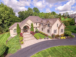
Real Estate
Bird's Eye View is happy to provide Western New York's real estate agents with high-quality aerial images and video with our amazing drones! We've worked with every major real estate company in the area and we'd love to work with you. Our team is guaranteed to capture that amazing perspective to help sell your property faster than ever before.


GIS Mapping, Point Clouds & 3D Models
The Bird's Eye View team utilizes drone technology to create GIS maps and point clouds for designers, architects, roofers, construction managers, surveyors and other clients. Through the use of photogrammetry software and advanced GPS systems, sUAS's can create georeferenced maps and dense point clouds for precise measurements and volumes with up to a single centimeter in project accuracy. We've helped with unique projects such as helping the US Fish & Wildlife Services monitor the dredging progress on Braddock Bay and we'd like to help your team next.
Contact Us to learn more about our mapping and rendering services.

